 Our Summer Trail Tour continues, as local runners share their favourite trails with the community. The Sunday following each feature, Health and Performance will lead a run on the trail for anyone to join. Read more about the Summer Trail Tour.
This week is the reprisal of last week’s Hydrocut: Part 1. Again, Luke Hoyt shares one of the region’s favourite trails. While many runners are at the Kitchener Kids with Cancer run at Homer Watson Park, if you missed the Hydrocut last weekend, here’s your second chance!
Group run at The Hydrocut
Date: Sunday, August 28, 2016
Time: 9:00am
Meet: Snyder’s Road Parking Lot
Length: 8-12 KM of trails
More details: All paces are welcome. The main group moves approximately 7:00/km. Runners have the option of turning around at any point to cut the run to their preferred distance or time.
Photos from The Hydrocut
The Hydrocut Trail System – Upper Section – Pines
The Hydrocut is an outstanding network of around 25km of singletrack trails on the west side of Waterloo. The trails are exceptionally managed and maintained by the Waterloo Cycling Club and are well signed. Though primarily used for mountain biking, the trails are free to the public to use for hiking and running as well. There is a continuously updated and very informative website that has a map, trail condition updates, forum for discussion and plenty of other info at your disposal.
The trails consist of two sections joined together by the hydro corridor. Last week, we tackled the easternmost/lower section/Landfill/Glasgow side. This week, we’re at the upper western section/Pines/Snyders Road section, also aptly named for the pine forest that the trails cut through and its entry point. The Snyders Road entrance is a bit trickier to find, but when you do, drive slowly and keep close watch for speed bumps, gravel trucks, and trains at the rail crossing.
This section is a bit of a different animal. The trail starts out on a multi-use trail that you can climb for about 1.5 kilometers and 50 meters up to another information kiosk that acts as a central jumping off point to the majority of trails in this section. Again, here you have the option of heading to the corridor and down to the Landfill side. The Pines will give you more elevation changes and turns with plenty more roots and rocks to keep you light on your feet and stepping high. There are quite a few blind corners so keep your eyes peeled for cyclists, which you can usually hear coming as they rattle over the aforementioned roots and rocks. And yes, more spiderwebs for you early risers.
Entire Trail Map
[sgpx gpx=”/wp-content/uploads/gpx/Hydrocut.gpx”]
Trail features
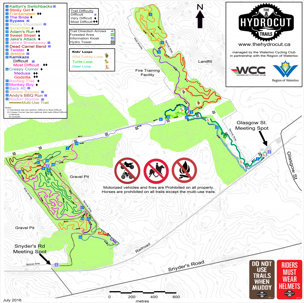
Access: The main access for the upper section is off Snyder’s Road, past the railway tracks.
Surface: Multi-surfaced, including board walks and bridges, switchbacks and “armoured” walls, with technical features.
Full length of the trail: 25 KM
Trail system: The Hydrocut trail system is consistently ranked as one of the top mountain bike destinations in Ontario and is recognized across Canada for its 25 km of continuous singletrack that see nearly 40,000 visitors per year. The trails are open and free to the public.
More information: can be found here.
Join Val, Luke and the group at West Side Trails on Sunday!